|
|||||||||||||||||||||||||||
|---|---|---|---|---|---|---|---|---|---|---|---|---|---|---|---|---|---|---|---|---|---|---|---|---|---|---|---|
| Station statistics | |||||||||||||||||||||||||||
| Address | Canal Street between Broadway & Centre Street New York, NY 10013 |
||||||||||||||||||||||||||
| Borough | Manhattan | ||||||||||||||||||||||||||
| Locale | Chinatown, Little Italy, SoHo | ||||||||||||||||||||||||||
| Division | A (IRT), B (BMT) | ||||||||||||||||||||||||||
| Line | BMT Broadway Line BMT Nassau Street Line IRT Lexington Avenue Line |
||||||||||||||||||||||||||
| Services | 4 (late nights) 6 (all times) <6>(weekdays until 8:45 p.m., peak direction) J (all times) N (all times) Q (all times) R (all except late nights) Z (rush hours, peak direction) |
||||||||||||||||||||||||||
| Connection | |||||||||||||||||||||||||||
| Structure | Underground | ||||||||||||||||||||||||||
| Levels | 2 (Broadway Line express platforms bisect 3 other lines) | ||||||||||||||||||||||||||
| Other information | |||||||||||||||||||||||||||
| Opened | September 4, 1917 (BMT Manhattan Bridge & Nassau St Lines) January 16, 1978 (IRT)[1] |
||||||||||||||||||||||||||
| Traffic | |||||||||||||||||||||||||||
| Passengers (2010) | 16,007,057[2] 0.2% | ||||||||||||||||||||||||||
| Rank | 15 out of 422 | ||||||||||||||||||||||||||
|
|||||||||||||||||||||||||||
Canal Street is a New York City Subway station complex in the Manhattan neighborhoods of Chinatown and SoHo, shared by the IRT Lexington Avenue Line, the BMT Nassau Street Line, and the BMT Broadway Line. It is served by:
Contents |
The complex consists of four originally separate stations joined by underground passageways. Three of the four are perpendicular to Canal Street, crossing at Broadway (Broadway Main Line), Lafayette Street (Lexington Avenue Line) and Centre Street (Nassau Street Line). The Broadway Manhattan Bridge Line platforms are directly underneath Canal Street itself. The Bridge Line platforms serve as the transfer passageway between all other lines. After leaving Canal Street, the Manhattan Bridge line makes a hard right onto Broadway.
This complex was fully renovated between 1999 and 2004. The Broadway Main Line station was restored to its original look with new mosaics featuring Chinese characters, reflecting the station's location in Chinatown. The symbols on the red wall plaques mean "money" and "luck" and the "Canal Street" name tablet has ideographs that read "China" and "Town." During the most recent renovation in the 1990s, the original mosaics were uncovered but then either removed or covered over again. One of the original tablets has been preserved at the New York Transit Museum.
Some relative depths of the stations in the Canal Street complex are as follows:
|
|||||||||||||||||||||||||||
|---|---|---|---|---|---|---|---|---|---|---|---|---|---|---|---|---|---|---|---|---|---|---|---|---|---|---|---|
| Station statistics | |||||||||||||||||||||||||||
| Division | A (IRT) | ||||||||||||||||||||||||||
| Line | IRT Lexington Avenue Line | ||||||||||||||||||||||||||
| Services | 4 (late nights) 6 (all times) <6>(weekdays until 8:45 p.m., peak direction) |
||||||||||||||||||||||||||
| Structure | Underground | ||||||||||||||||||||||||||
| Platforms | 2 side platforms | ||||||||||||||||||||||||||
| Tracks | 4 | ||||||||||||||||||||||||||
| Other information | |||||||||||||||||||||||||||
| Opened | October 27, 1904[3] | ||||||||||||||||||||||||||
| Accessible | (not accessible to other routes) | ||||||||||||||||||||||||||
| Station succession | |||||||||||||||||||||||||||
| Next north | Spring Street: 4 6 <6> | ||||||||||||||||||||||||||
| Next south | Brooklyn Bridge – City Hall: 4 6 <6> Worth Street (closed) |
||||||||||||||||||||||||||
|
|
|
||||||||||||||||||||||||||
| Next north | Grand Central – 42nd Street: 4 6 <6> | ||||||||||||||||||||||||||
| Next south | Brooklyn Bridge – City Hall: 4 6 <6> | ||||||||||||||||||||||||||
|
|||||||||||||||||||||||||||
Canal Street on the IRT Lexington Avenue Line is a local station that has four tracks and two side platforms. Due to platform lengthening in the 1940s and 1950s, there are two distinct sections of this station. The original portion has tile-covered I-beams with small and large mosaics and an ornamental ceiling. The newer portion has 1950s green tile at the end of the platforms. There are also IND-type "To Canal Street" signs. New lights are being installed. Non-original name tables and small "C" mosaics exist.
|
|||||||||||||||||||||||||||
|---|---|---|---|---|---|---|---|---|---|---|---|---|---|---|---|---|---|---|---|---|---|---|---|---|---|---|---|
train arriving going south |
|||||||||||||||||||||||||||
| Station statistics | |||||||||||||||||||||||||||
| Division | B (BMT) | ||||||||||||||||||||||||||
| Line | BMT Nassau Street Line | ||||||||||||||||||||||||||
| Services | J (all times) Z (rush hours, peak direction) |
||||||||||||||||||||||||||
| Structure | Underground | ||||||||||||||||||||||||||
| Platforms | 2 island platforms (1 in regular service) | ||||||||||||||||||||||||||
| Tracks | 3 (2 in regular service) | ||||||||||||||||||||||||||
| Other information | |||||||||||||||||||||||||||
| Opened | August 4, 1913[4] | ||||||||||||||||||||||||||
| Station succession | |||||||||||||||||||||||||||
| Next north | Bowery: J Z | ||||||||||||||||||||||||||
| Next south | Chambers Street: J Z | ||||||||||||||||||||||||||
|
|||||||||||||||||||||||||||
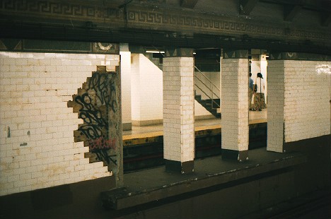
Canal Street on the BMT Nassau Street Line has three tracks and two island platforms, but only the western island platform is accessible to passengers. Formerly, Canal Street resembled a typical express station except that the inner tracks dead-ended at bumper blocks at the south end with a platform-level connection joining the southern ends of the two platforms. These stub-end tracks were last used in the mid 1990s when weekend J service ended here instead of Chambers Street.
After a reconfiguration of the Nassau Street Line in 2004, the eastern (former "northbound") platform was abandoned and now used as a storage area and the platform-level connection was removed, allowing the former southbound express track to continue south. The westernmost (former "southbound") platform remains in operation and both tracks provide through service with southbound traffic using the former southbound "local" track and northbound traffic using the former southbound "express" track. The former northbound local track is now used only for non-revenue moves, train storage and emergencies while the northbound express stub track was removed.
This station was completed at the end of 1909 and included a bridge over the proposed Canal Street subway to cross underneath.[5] Part of the Canal Street subway was built and is part of the Manhattan Bridge Line.
Delayed by construction of the Chambers Street, this part of the Nassau/Centre Street subway opened in August 1913.
There is an opening in the center wall about fifty feet from the end of the station[6] that has a narrow platform. This was used by train crews to cross between trains on the center tracks.
South of this station there are unused trackways curving towards the Manhattan Bridge.[7]
In the renovation, the original "Canal Street" mosaics were restored, and new wall and floor tiling were installed.
|
|||||||||||||||||||||||||||
|---|---|---|---|---|---|---|---|---|---|---|---|---|---|---|---|---|---|---|---|---|---|---|---|---|---|---|---|
Brooklyn-bound train of R68 cars arriving at the Bridge Line platform |
|||||||||||||||||||||||||||
| Station statistics | |||||||||||||||||||||||||||
| Division | B (BMT) | ||||||||||||||||||||||||||
| Line | BMT Broadway Line | ||||||||||||||||||||||||||
| Services | N (all times) Q (all times) R (all hours except late nights) |
||||||||||||||||||||||||||
| Structure | Underground | ||||||||||||||||||||||||||
| Levels | 2 | ||||||||||||||||||||||||||
| Platforms | 4 side platforms (2 on each level) | ||||||||||||||||||||||||||
| Tracks | 6 (4 upper level, 2 of them not for passenger service, 2 lower level) | ||||||||||||||||||||||||||
| Other information | |||||||||||||||||||||||||||
| Opened | September 4, 1917[8] (Manhattan Bridge) January 5, 1918[9] (Broadway Line) |
||||||||||||||||||||||||||
| Former/other names | Broadway (lower level) | ||||||||||||||||||||||||||
| Station succession | |||||||||||||||||||||||||||
| Next north | Prince Street (local): N R 14th Street – Union Square (express): Q |
||||||||||||||||||||||||||
| Next south | City Hall (via Tunnel): N R DeKalb Avenue (via Bridge to Brighton): Q Atlantic Avenue – Pacific Street (via Bridge to Fourth Avenue): N Myrtle Avenue (via Bridge, closed) |
||||||||||||||||||||||||||
|
|||||||||||||||||||||||||||
Canal Street on the BMT Broadway – Main Line has four tracks and two side platforms. Only the outer local tracks provide through service on the BMT Broadway Line (N R trains) via the Montague Street Tunnel. The center "express" tracks, which have never seen revenue service, begin at the lower level of City Hall and run north to Canal Street, dead-ending at bumper blocks about two-thirds of the way through.
As part of the Dual Contracts, these express tracks were to have continued up Broadway, fed by traffic from Brooklyn and the Montague Street Tunnel; local service was to have terminated at the upper level of City Hall. That plan was dropped prior to the line's completion. A new plan favored local service via City Hall's upper level, reconstruction south of that station to join the local tracks with the rest of the line and express service via the Manhattan Bridge. Thus, City Hall's lower level was abandoned during construction and never placed in service. Today, just north of this station, the tracks from the lower level curve north, rise up and replace the stub-end express tracks from City Hall's lower level.
In the late 1970s, New York City Transit fixed the station's structure and overall appearance by replacing the original wall tiles, old signs, and incandescent lighting to 70's style wall tiles, signs and fluorescent lights. They also fixed staircases and platform edges.
In 2001, the upper level received a major overhaul before the lower level reopened. Among the repairs included the staircases, re-tiling for the walls, new tiling on the floors, upgrading the station's lights and the public address system, installing ADA yellow safety threads along the platform edges, new signs, and new track beds in both directions.
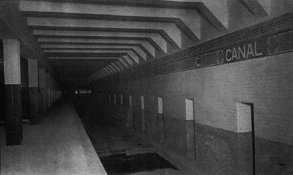
Canal Street on the BMT Broadway – Manhattan Bridge Line has two tracks and two side platforms. When it originally opened, this station was known as Broadway. Although technically located on the BMT Broadway Line, it was originally a distinct station from the main line. Located on the lower level and oriented perpendicular to the other portions of the complex, it is served by the N Q trains. Northbound, trains enter from the south tracks of the Manhattan Bridge. After the station, the bridge tracks curve north, and ramp up to form the express tracks of the Broadway Line.
Under the Dual Contracts, this station was meant to be part of a crosstown line under Canal Street, running from the Manhattan Bridge to the Hudson River, or towards West Street; however, prior to the opening of the Broadway Line, the BMT decided to route Manhattan Bridge traffic to the Broadway express tracks instead. After the lower level tracks curve north from the Bridge Line platforms, the tunnel continues straight ahead, past the diverge to the Broadway line. The bellmouths going westward from the west end of the station are a provision from the original plans and run for about 100 feet. Also, sitting on one of the trackways is a storage building.
The original tile on this station read simply "Broadway" and there was a small either wood or metal sign attached to the wall beneath the tile name that read "Canal Street."
With the exception of a three-month period in 1990, train service to these platforms was suspended from 1988 to 2001 during the Manhattan Bridge reconstruction project. The platforms remained open as the transfer passageways between the rest of the complex. Service between Manhattan and Brooklyn was redirected to the Main Line platforms and the Montague Street Tunnel. The three-month period was supposed to have allowed train service while work on the bridge was not being done, but on December 27, 1990, the discovery of missing steel plates and corrosion that threatened the bridge's integrity halted this service.[10][11] In 1997, a temporary art exhibit known as the Canal Street Canal by Alexander Brodsky, was installed on the northbound trackway. It consisted of a large waterproof tub filled with water, with Venetian canal boats floating inside.[12] The platforms reentered revenue service on July 22, 2001 with new tiling on the floors, upgraded lights and public address system, ADA yellow safety threads along the platform edge, new signs, and new trackbeds in both directions.
East of this station are the trackways leading from Chambers Street on the BMT Nassau Street Line. These trackways led onto the Manhattan Bridge south side tracks, while Broadway trains ran on the north side tracks of the bridge. These tracks were disconnected as part of the Chrystie Street Connection in 1967 and no longer have rails or any other infrastructure.